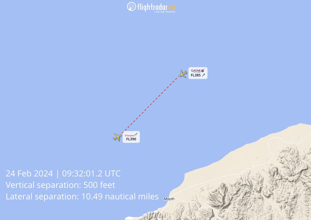
A series of incidents involving erroneous climb and descent instructions from unofficial air traffic controllers in the Mogadishu FIR culminated last week in a TCAS event between an Ethiopian Airlines A350 and a Qatar Airways 787. The Qatar flight was instructed to climb from FL380 (38,000 feet) to FL400 while the Ethiopian flight was traveling at FL390 in the opposite direction. A Traffic Collision Avoidance System (TCAS) Traffic Advisory alerted both crews to the potential conflict and the Qatar 787 descended back to FL380. At the time of minimum vertical separation (500 feet), the two aircraft were 10.49 nautical miles apart on non-intersecting paths.
We have downloaded and processed the raw ADS-B data for both aircraft to provide a clearer picture of the incident. All times listed below are in UTC and are the times at which signals from each aircraft were received by Flightradar24 ADS-B receivers in the area.
Qatar Airways flight 1383, operated by Boeing 787-8 A7-BCN was traveling from Doha (DOH) to Entebbe (EBB) along airway UB404 off the northern coast of Somalia over the Gulf of Aden. Ethiopian Airlines flight 602, operated by Airbus A350-951 ET-ATY was traveling in the opposite direction on the same airway from Addis Ababa (ADD) to Dubai (DXB). Both aircraft were adhering to Strategic Lateral Offset Procedures or SLOP, which permits an aircraft to fly the right of the assigned track or airway, increasing lateral separation with any oncoming traffic.
Around waypoint ESTIK, the Qatar 787 was instructed via CPDLC to climb from FL380 (38,000 feet) to FL400 (40,000 feet) by Mogadishu Control. The flight passed ESTIK at approximately 09:30:32 UTC. At 09:30:56 UTC ADS-B data shows a change in the selected altitude on the 787’s mode control panel from 38,000 to 40,000 feet.
The 787 climbed to a maximum altitude of 38,500 feet at 09:31:57 when the Qatar crew stopped the climb and began descending back to 38,000 feet. The autopilot on the 787 disconnected 09:32:03 as the aircraft descended through 38,450 feet. At 09:32:20 the autopilot was re-engaged with a selected altitude of 38,000 feet.
Ethiopian Airlines issued a statement saying that Ethiopian flight 602 “encountered a Traffic Advisory (TA)” at 09:32, which is consistent with the ADS-B data received from both aircraft. Traffic Advisories are the less severe advisory issued to aircraft that require crews to be aware of potentially conflicting traffic. A Resolution Advisory requires immediate action as directed by the TCAS system. As the TCAS TA does not require the aircraft to change their path, the Ethiopian Airlines A350 continued flying at 39,000 feet.
Post-incident follow up
After passing each other, both aircraft continued to their destinations safely. A short time after the aircraft passed, Qatar 1383 was re-cleared to FL400 (shown in the selected altitude chart above).
For its part, Ethiopian Airlines confirms it reported the incident to Somali and Ethiopian authorities. This incident comes after Mogadishu Control issued a NOTAM on 19 February warning against VHF interference.
A0022/24 NOTAMR A0017/24 Q) HCSM/QCALF/IV/B/E/000/999/0514N05041E999 A) HCSM B) 2402191830 C) 2403312359 EST E) UNLAWFUL VHF INTERFERENCE ON FREQ 132.5 MHZ AND 118.7 MHZ WITHIN 150NM CENTERED ON POSITION HARGA (093121N0440530E). FLIGHTS WITHIN THIS AREA SHOULD NOT EXPECT LEVEL CHANGE UNLESS IN CONTACT WITH MOGADISHU ACC VIA CPDLC (HCSM) OR THE FOLLOWING SATCOM NUMBERS
Unfortunately in this instance, the clearance was given by datalink from controllers in Mogadishu. The crews of both aircraft were able to quickly manage the situation, but it is a reminder of the continued risk to aircraft operating in the area.
The post TCAS incident highlights ongoing issues in Somalia airspace appeared first on Flightradar24 Blog.
