Techniques such as ground penetrating radar can be used to detect underground utilities up to five metres underground, but traditionally, analysis of this raw radar data requires technical expertise, extended wait times and is expensive to produce. Reveal, the innovative underground experts, have developed a new rapid point-cloud visualisation called Underdots that promises to speed up the data processing and deliver faster insights.
Underdots is an online data processing service that transforms multi-channel GPR data into a 3D point-cloud visualisation, providing designers with rapid insights into the intensity and depth of radar reflections, and helping to identify underground utilities in large areas.
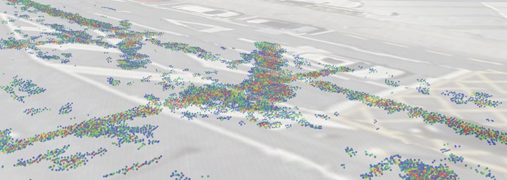
The Underdots point-cloud visual is a collection of clustered dots plotted in a 3D GIS environment showing the intensity and depth of radar reflections. This creates an intuitive 3D model that gives designers clear indications of the presence or absence of unseen utilities.
In addition, utilities coordinators can compare the Underdots visualisation to existing utility plans to determine where further invasive investigations such as potholing should be conducted, as well ‘green-flagging’ regions where the Underdots detections match the expected findings.
Underdots supports data exports from popular multi-channel GPR systems including Kontur DX, Mala Mira and IDS Stream UP/X. Clients upload data to the cloud service at https://www.underdots.com and receive a unique link to a mapping environment that can be shared with all project stakeholders.
Case study: let’s get wellington moving
Reveal was contracted by Waka Kotahi, the New Zealand Transport Agency, to provide utility locating services and create a detections model of the underground utilities along major transport routes for the Let’s Get Wellington Moving project.

Underdots is a collection of clustered dots showing the intensity and depth of radar reflections.
The Underdots service was used to rapidly process data sets collected from Reveal’s own vehicle-mounted multichannel ground-penetrating radar (GPR). The data collected from the city centre revealed a series of previously unknown detections such as reinforced concrete and historic tram tracks. After a full investigation, the Underdots process successfully identified 47,095sqm of reinforced concrete and 29,600m of buried tram tracks.
These anomalies, if left undetected, would have resulted in major delays, as well as disruption to local businesses and commuters along the traffic routes. Project managers would have been required to take reactive action in resource management and rework construction plans, as the reinforced concrete requires specialist heavy machinery to break through. A similar process was required for removing sections of the remaining tram track rails.
In this case, due to the early detection provided by Underdots, project designers were able to adjust plans accordingly before implementing invasive and publicly disruptive work.
Underdots is available now. Visit https://www.underdots.com today to learn more.